You can pick up an Art Trail guide to plan your trail or create an account on our website and plan your trail online. Our website has all the same features as the printed guide, as well as the ability save your favourite artists and plan your route using Google Maps.
Plan your trail online and you'll automatically go in the draw to win a $300 Art Trail voucher to spend with any of our Art Trail artists.

Create an account and save artists to your 'My Favourites' list. You can then plan your route on our map so you can follow your trail easily on your phone using the Google Maps app.
If you've forgotten your password. Click forgot password and enter your email address. Check your inbox and click the link in the password recovery email and then click change password details.
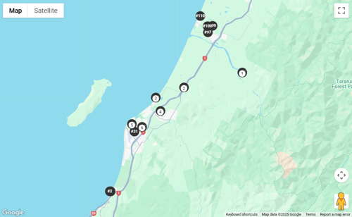
On My Favourites you'll see a map below your list with black dots showing your favourite artists' listing number – the same number as in the printed guide. Simply click on the black dots in the order you want to visit and open your route in Google Maps.
Having problems? See more detailed instructions below.
How to plan your route:

You can pick up an Art Trail Guide from cafes, galleries, libraries, local businesses and Coastlands Shopping Town. Outside the district you should be able to find guides at your regional art gallery or tourist site, or email us and we’ll post one to you. You can also download a digital copy of the guide.
In the guide, you'll find:
All of the art works are treasures, and many studios are in artists' homes and gardens, so please:
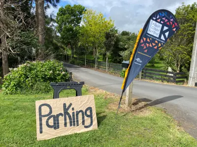
There are many ways to visit the many creative spaces and charming coastal gardens on the trail.
Kāpiti is perfectly placed – just 50km north of Wellington, within easy reach from the Hutt Valley, Wairarapa, and Palmerston North. Whether you’re planning a weekend escape or a day trip, getting here is a breeze. Travel by car, train, bus, or plane – every route leads to coastlines, creativity, and a weekend that feels a little like a holiday.
From Wellington, take State Highway 1 via Transmission Gully – around 35 minutes from Wellington City to Kāpiti.
Prefer a slower, more scenic drive? Follow State Highway 59, winding along the coastline and through the charming village of Paekākāriki.
Coming from the Hutt Valley (Lower or Upper Hutt)? Head over Haywards Hill (SH58) and connect with SH1 at Pāuatahanui for a smooth run north via Transmission Gully.
Travelling from the Wairarapa? Take SH2 over the Remutaka Hill, then follow SH58 to join SH1 north to Kāpiti.
From Palmerston North, it’s an easy drive south – about 1 hour 15 minutes via SH1, or you can take the scenic SH57 and SH59 route along the coast for a relaxed start to your Art Trail weekend.
Sit back and relax! Metlink’s Kāpiti Line runs from Wellington Station to Waikanae every 30 minutes, stopping at Paekākāriki, Paraparaumu, and Waikanae along the way – perfect for a car-free Art Trail weekend.
If you’re coming from the north, Palmerston North connects to the Kāpiti Coast via inter-regional train services that link with Metlink trains at Waikanae or Paraparaumu, making it easy to join the Trail from further afield.
InterCity operates daily buses toParaparaumu from locations across the North Island. All services arrive at Paraparaumu train station, making transfers easy.
Flying in? The Kāpiti Coast Airport is right in the heart of Paraparaumu, with daily flights to Auckland, Christchurch, Nelson, and Blenheim via Sounds Air and Air Chathams.
Taxis, shuttles, and rental cars are available on arrival. The Paraparaumu Train Station is just 5 minutes away, with regular services north to Waikanae or south to Wellington.
Wellington International Airport is also an easy 60km drive north to Kāpiti via SH1.
Alternatively, Palmerston North Airport is 100km away (about 1 hour 15 minutes by car).
A wonderland of unspoilt beaches, stunning natural landscapes, vibrant local artisans, and foodie delights – Kāpiti is the perfect place to unwind and explore.
Make a weekend of it! Here the sun shines brighter, the sunsets are unrivalled, and it’s all just a quick skip from the hustle and hurry of Wellington City. Whether you’re hitting the trails or simply enjoying the sand between your toes, our 40-kilometre slice of paradise is waiting for your footprints.
Treat yourself to a coastal escape – discover cosy stays, seaside eateries, and perfect Art Trail pit stops from a leisurely long lunch to your essential coffee fix along the way.

Find the best places to eat, play, and stay – plus itineraries and local guides...
Browser requirements:
We use Google Maps to display artist locations. This requires a modern browser. To the best of our knowledge, current Chrome, Edge, and Firefox all support the full set of Google Map features. Since browser versions prior to that were released several years ago, they are currently not supported for use with the Google Maps.
